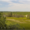
Real-time Data
Access real-time data on water levels, water quality, and weather conditions within
North Inlet and Winyah Bay by a network of continuous monitoring stations operated
by the North Inlet-Winyah Bay National Estuarine Research Reserve.

Water Levels
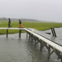
The North Inlet-Winyah Bay (NIWB) NERR tracks and reports tide heights in near-real
time at the Oyster Landing research pier using a Hohonu ultrasonic sensor.
NOAA provides tidal predictions for locations within the North Inlet estuary, including
Oyster Landing (Station ID: 8662245) and Clambank Creek Dock (Station ID: 8662299).
Weather
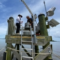
The NIWB NERR meterological station at Oyster Landing pier collects near-continuous
weather data as part of the NERR System-wide Monitoring Program (SWMP).
Data are available from the NERR Centralized Data Management Office's (CDMO) Real
Time Application (Station ID: NIWOLMET)
Water Quality
The NERR's SWMP program collects water quality data (including temperature, salinity
and dissolved oxygen) at 15 minute intervals from six locations within North Inlet
and Winyah Bay.
Data are available via the NERR CDMO's Real Time Application for three of the six
sites:
- Oyster Landing (Station ID: NIWOLWQ),
- Winyah Bay Surface (Station ID: NIWWSWQ)
- Winyah Bay Bottom (Station ID: NIWWBWQ).
Webcams
Multiple cameras around the Baruch Institute facilities offer live views of North
Inlet estuary's salt marshes, oyster reefs, creeks, and critters (researchers included,
of course).